Every car a potential bomb, every roof
a potential RPG or sniper's nest.

Pick the emergency LZ
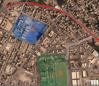
These are Google Earth images of Ramadi, a place the US does not control.
For some reason, people are allergic to maps, but since I was a Boy Scout, I love them, and nothing is better than Google Earth, not even the online Perry-Casteneda collection
Look at the first image. Every dot is a car.
And every car is a potential bomb.
Let's say, and the two sites are chosen randomly from the map, are two potential rally/evacuation points from the center of town.
The red line is the road, the white, access roads.
Blue Zone A is an open parking lot, and so is Green Zone B.
Oh, and that close up? It's of the buildings between the two lots. In peace time, a 10 minute walk, five minute drive. Now? They're pretty much isolated.
Now, A and B are on access roads. But A has low lying buildings and B has a warehouse. A has a slightly shorter flying time to the highway, which is the way out.
What you get to figure out is which will be easier to gather people in, get machines in and out and protect the landing zones for as long as needed.
Now, I have no answers. But what you need in mind is that if we have to fight our way out of Iraq, this is the kind of decisions we will have to make on the spot.
No comments:
Post a Comment